Saturday, October 4, 2014

Black Diamond ReVolt Headlamp Helps Hiker Survive Owl Attack

by Brian Schwarz

Trail-testing the Black Diamond ReVolt rechargeable headlamp
This evening, just after dark, I was testing out some new gear near Pinnacle Rock in Washington, D.C.'s Rock Creek Park - a Black Diamond ReVolt headlamp I bought at Hudson Trail Outfitters earlier this week (using their online price match guarantee for a great deal, I might add). I'd been hanging out on the bluffs overlooking Rock Creek as the sun went down, and had started snapping some test shots to post on Twitter and Instagram as teasers for my review. Then, once the woods had pretty much turned pitch black, I started to head down the Theodore Roosevelt Trail to return to my car, eerily aware that since I'm a day hiker, I wasn't quite sure what to expect on my first hike after dark.

Testing the Black Diamond ReVolt at Pinnacle Rock, Rock Creek Park
No sooner had I had that thought than a huge bird flew out from behind a trail-side stump and perched on a low-hanging branch nearby. Wow! I was able to see all the action, thanks to the ReVolt's 130 lumens and bright TriplePower LED. At first I was startled by the burst of energy from the forest floor, but I quickly regained composure and trained my headlamp on the branch. I noticed a huge barred owl was facing away from me looking down toward the creek.

"Oh, cool!", I thought, as I took a moment to attempt to snap a photograph of this magnificent nocturnal creature not 15 feet away from me. But just as I had my phone camera trained on the owl, it turned its head around like a horror movie doll and stared directly at me, its eyes aglow in the headlamp's beam. The owl's glare was long enough to send chills down my spine. Then it twisted its head mechanically back around to watch the creek.

I clumsily shoved my phone back in my pocket, deciding I should probably move along and get back to my car before things got weird. This owl was obviously on the hunt.

Heading down the trail near Pinnacle Rock, as darkness takes over the forest
I know enough about the natural world that I quickly realized sticking around on the bluffs high above a creek just around the time the nocturnal hunters were coming out in search of prey was not a good idea. But before I'd even processed that thought fully and walked more than five steps down the trail, I heard a quick rush of wind from behind. Thwap! I was attacked!

Just like that, the talons of the great barred owl attempted to snatch onto my bald head, knocking me forward on the precariously narrow bluffs trail. Then, as quickly as it had attacked, the owl disappeared again, silently slipping away somewhere into the hushed calm of the urban forest.

I didn't stop to figure out where it had gone, or to see if it was still somewhere close and ready to attack again. I just assumed it would if I stood still. So instead, I took off my backpack and began to swing it around my head as I carefully sprinted down the dark trail, relying only on my Black Diamond ReVolt headlamp to guide me safely to the trailhead.

Descending the Roosevelt Trail, moments before the owl attack
As if one encounter with the wild creatures of the night weren't enough, as I was running down the trail I noticed a dark figure running briskly along the shoreline of Rock Creek, at a lower elevation than me but on a parallel trajectory. It didn't run like a deer, more like a coyote. It couldn't have been a dog; I'd been alone on the trail now for more than an hour. But could coyotes be down this far south in the park, I wondered? Sheesh, this was beginning to be too much to think about on my first ever nighttime outing!

The dark figure disappeared, and I kept flailing and making a bit of noise as I carefully but quickly hopped rocks and roots along the Roosevelt Trail with one goal in mind - reaching the safety of my car, parked across the creek along Broad Branch Road.

When I made it down to Beach Drive, several cars were passing by, though no runners or bikers were anywhere to be found. Maybe they knew something I didn't about the kinds of animalistic activities that go on in Rock Creek Park after the sun goes down. In any case, I darted to my car, jumped inside and began to drive.

As I navigated my way back across town to Park View, I felt a stinging sensation in the back of my head. I reached around, and it stung even more under the touch of my salty hands. I knew I'd been scratched at the least. But it was too dark in the car to tell if I was bleeding. When I got home, I realized that I was in fact bleeding, but only slightly. So I administered first aid, took a few photos of the back of my head to see what the talon marks looked like, and decided to go online and research owl attacks, since before tonight I can't say I recall ever hearing that owls attack humans.

Talon marks from the barred owl that attacked me (with Remy photobomb)
It turns out, it's not normal for owls to attack humans. However, according to a Washington Post article from 2012, several runners were reportedly attacked by owls that fall. National Park Service Ranger Ken Ferebee was consulted on the matter, and he directed the question to the Global Owl Project to find a very probable explanation for why such owl attacks might occur.

According to the Washington Post article, on occasion, people have been known to come across a baby owl before it can fly and, believing it to be abandoned by its mother, they "rescue" it. As a result of such novice intervention, Global Owl Project Director David Johnson said, "rescued" owls soon grow too big to be cared for by novices, and so these ignorant do-gooders release the now domesticated owl back into the wild where they lack the skills to hunt and survive on their own. Not knowing how to hunt, the owl then mistakenly turns on humans, the only animal it grew up having any knowledge of.

So there you have it! I was attacked by a barred owl in Rock Creek Park, and I learned a few things as a result. The most salient lesson of all is that if you are going to be hiking at night, you need a quality headlamp that will not only show you the way but be able to help you respond quickly should an unexpected emergency arise. Now, I haven't trail tested any other headlamps, but I can tell you that the ease of use of the Black Diamond ReVolt headlamp - notably the ease at which I was able to redirect the beam while being chased by an angry owl down a narrow bluffs trail - made me extremely happy with my purchase.


Brian Schwarz is a freelance writer and outdoor leader based in Washington, D.C. He often leads hikes in Rock Creek Park and the surrounding areas, which are posted on the Facebook page Hiking Megalopolis. Contact Brian via the comment section below, and for links to his social media activity, refer to his splash page at about.me/brian.schwarz.

Tuesday, September 30, 2014

Hiking DC's Rock Creek Park - Southern Bluffs and Rapids Section

by Brian Schwarz

Rock Creek Park is a swath of preserved parkland located in Northwest Washington, DC. Managed by the National Park Service with hiking trails maintained by the Potomac Appalachian Trail Club, Rock Creek Park is a haven for urban hikers. Still, despite being well within the urban core of the nation's capital, Rock Creek's trails offer hikers a surprising amount of solitude.

This hike in the rocky southern section of Rock Creek Park begins at historic Pierce Mill. From the Pierce Mill parking area, take the green-blazed Western Ridge Trail north along the Rock Creek flood plain. Carefully cross Broad Branch Road and continue to follow the green blazes up a steep hill to cross Glover Road, soon after which you will reach Equitation Field. 

View from Rapids Bridge of Rock Creek, along the Fall Zone
Keep going on the Western Ridge Trail until you reach the signed Picnic Area 17. Here, cross Glover Road and find unmarked horse trail, identified on the PATC Map N Rock Creek Park map as CT7. Cross trail 7 joins CT6 after you traverse Ross Road at the picturesque Ross Road Bridge. Soon you will reach the flood plain once again. Turn left when you see Rock Creek and walk to Rapids Bridge, where you will cross the bridge to enjoy one of the most scenic views along Rock Creek. This is the Fall Zone, where the Piedmont physiographic province yields to the Atlantic Coastal Plain.

After enjoying views of the boulder-strewn waters, continue across the bridge, and then cross Beach Drive to join the blue-blazed Valley Trail. Turn Right. Stay on the Valley Trail as you pass by Boulder Bridge, where president Theodore Roosevelt once lost a precious gold ring that was never recovered, and climb to the precipice known as Pulpit Rock, a great place to rest and refuel.

Continue on the Valley Trail and soon you will cross Blagden Avenue, then later Park Road and Beach Drive once again. As you once again reach the banks of Rock Creek, turn left, to the end of the Valley Trail at Bluff Bridge.

Cross Bluff Bridge and turn right to join the Western Ridge Trail, at the base of a hill topped by Klingle Mansion, which houses Rock Creek Park Headquarters. Several yards on, you must choose the strenuous or moderate route to continue on the Western Ridge Trail.

The strenuous route is more scenic but requires some light bouldering (grabbing onto boulders to navigate obstacles in the trail). Along the moderate route you will find a spur trail that leads to Klingle Mansion. Just beyond the point where these two routes converge is your starting point at Pierce Mill.

Trailhead: Find the Pierce Mill parking area along Park Road, just west and across Rock Creek from Beach Drive. This hike is also accessible via the Metro Red Line. From Vann Ness - UDC Station walk south on Connecticut Avenue to Tilden Street and walk east. Also, You may take H2, H3, or H4 Metrobus to the corner of Klingle Avenue NW and Park Road NW, then walk north on Park Road to Pierce Mill. Each of these public transit routes add approximately one mile, round trip.
Distance: Approximately 3.5 miles round trip
Elevation Gain/Loss: Approximately 400 feet, spread out between several hills
Map: A free map is available from the National Parks Service here. However, for a more enriching experience hiking Rock Creek Park, I recommend purchasing Map N: Trails in the Rock Creek Park Area, from the Potomac Appalachian Trail Club, available for purchase here.
Hiking Time: 1.5 to two hours round trip, depending on your personal speed and how often you take breaks to enjoy the views.
Best Times to Hike: This hike can be done year round.
Difficulty: Easy

For more information on this hike or other hikes discussed in the blog HikeyHikey, feel free to leave a comment below. Also, check out my other blogs Man of Merit and MyFitLife2Day and HikingMegalopolis. Or contact me via my splash page at about.me/brian.schwarz

Thursday, September 25, 2014

Hiking Philadelphia - West Fairmount Park Great Woods Loop

by Brian Schwarz

Most Philadelphia area hikers know about hiking the Wissahickon Gorge, but few realize some of the best trails lie tucked away between the Schuylkill Expressway, West Philadelphia and City Avenue. That's right, West Fairmount Park is so close to the Center City that no one suspects that it's home to an in-tact contiguous woods, with an easy-to-follow 5-mile hiking loop that leads through the urban wilds and only crosses a busy park road once!

Mountain bikers and competitive cross-country runners already know about sections of these great trails. Still, strikingly few hikers take the time to get to know this truly unparalleled hiking experience. Despite their proximity to the heart of the city, this is not some second-rate hike you do when you can't make it to the Wissahickon, the Reading Prong, Blue Mountain or the Poconos. Hiking the great woods of Philadelphia's West Fairmount Park actually feels like entering the lungs of this great city.

Topo map shows terrain, beneath the trees of West Fairmount's Great Woods
Most people who have been to West Fairmount Park are probably most familiar with aspects of the Centennial District, which includes the Philadelphia Zoo, the Horticultural Center with its Japanese Garden, the Mann Center for Performing Arts and the Please Touch Museum in Memorial Hall. Many also know the many picnic areas and the spectacular view to be seen of the Philadelphia skyline from the Belmont Plateau. But fewer know of the woods that lie east of the plateau, on either side of the ridge where you'll find Chamounix Drive and the multi-use Speedway Trail.

The Great Woods of Fairmount Park can be divided into two parts, Belmont Woods and Chamounix Woods. The Belmont Woods is a unique urban-riparian experience.  Bound by Greenland Drive to the north, Chamounix Drive to the west and the sweeping grassy knoll of Belmont Mansion to the south. It is bound by the Schuylkill Expressway, too, and the trails here dip down below the massive interstate highway taking you into quiet wetland zones where creeks trickle down through a mixed-growth forest. Trees that are hundreds of years younger trees, providing a unique forest experience with a high canopy and a dense understory. It's an experience that rivals and even tops many Pennsylvania state forests, most of which are still quite young in comparison.

The Great Woods of Fairmount Park - Belmont and Chamounix

The Satellite image above shows the near contiguous Great Woods of Fairmount Park. Notice where the Strawberry Mansion Bridge enters the picture, crossing the Schuylkill River on the bottom right of the photo. As the road enters the park it is called Greenland Drive until it reaches Chamounix Drive. Belmont Woods are to the left of Greenland and extend all the way to the edge to the grassy area in front of Belmont Mansion. The woods north and west of Chamounix Road stretch as far north as the Schuylkill Expressway - right up to the I-76/Roosevelt Boulevard interchange - then wraps around Chamounix Hill to continue back to Greenland Road.

Here's the best part - the Great Woods of Fairmount Park is home to an extensive network of wilderness trails that nearly ANYONE can do and where EVERYONE is welcome. That's right - you don't have to be a moneybags or have special equipment and such to enjoy these woods! Just strap on a sturdy pair of shoes, carry water and snacks, and carry a pack so you can haul out any trash you make while enjoying the woods. These are the people's woods!

Don't worry that the trails back in these woods are not marked; you can trust all of the trails to lead you eventually to a road. If there is a trail back there that just peters out and doesn't go anywhere - and I haven't found one yet after at least 15 trips to scout trails - then just turn back around and take another route. That's what's so amazing - you're never far from a way out of the woods, yet you could get lost in there for as long as you choose to. These Philadelphia woods are the epitome of the urban wilds.

GPS Map of the Great Woods Hike in West Fairmount Park
The above map shows a recent 5.3-mile hike I took, starting at the Chamounix Mansion Youth Hostel (see the green dot?) and doing a loop of the entire Great Woods Hike. During the hike, I only crossed traffic once - at the intersection of Belmont Mansion and Chamounix Drives, which, as it turns out, is at the three-mile mark, an excellent place to stop and have lunch at the Chamounix Picnic Area.

The road crossings at Ford Road and Greenland Drive each have wooded pedestrian crossings, where if you'd like to exit the woods you may, but you certainly don't have to. Just to give you an idea of how long it would take to do this 5..3-mile loop, I did the entire thing in about three hours, taking several breaks to sit beneath the towering trees and listen to the many birds that call these woods home. Because it is at once so accessible while feeling so remote, you can break up the hike any way you choose and still walk out of the woods feeling refreshed.

So are you ready to explore the Great Woods of Philadelphia's West Fairmount Park? Follow this link to sister blog Hiking Megalopolis for a description of an epic loop hike that begins at Historic Strawberry Mansion, just across Strawberry Bridge in East Fairmount Park.

Also, for more information of other opportunities to explore the urban wilds and other hiking areas throughout Southeastern Pennsylvania and beyond, go to Facebook and like the Hiking Megalopolis community page. Free hikes are often listed. And please, TELL YOUR FRIENDS you saw it on Hiking Megalopolis!

Wednesday, June 11, 2014

Hiking Philadelphia's East Fairmount Park Woods Trails

by Brian Schwarz

Have you ever driven along the Schuylkill Expressway or Kelly Drive and wondered what mysteries might be hidden there in the woods, beyond the rush of traffic?

Those drawn to East Fairmount Park typically stick to either the Schuylkill River Trail - that thin sliver of pedestrian traffic wedged between Kelly Drive and river's edge. Or they make their way up the hill, to the ball fields or to explore the old stately homes abutting the historic Strawberry Mansion, and Fairmount neighborhoods.

Far fewer find their way into the woods here, but this post on Hiking Philadelphia's East Fairmount Park Woods Trails aims to remedy that.

Lemon Hill Trail

You will find the start of the East Fairmount Park Woods Trails across the street from the north side of the Philadelphia Museum of Art, near the intersection of Kelly and Fairmount drives. As you stand on the corner you'll notice the begining of a faint dirt path that runs paralel to the west, between Kelly Drive and Pennsylvania Avenue. Take this path as it goes past a playground and leads into the woods at 27th Street. This stretch of the Two Block Woods turns downhill after the 29th Street pedestrian bridge. Then, you must cross Sedgley Drive and find where the trail picks up into the woods and wraps around to the front of Lemon Hill Mansion.

Uplands view from the Lemon Hill Trail of the Shuylkill River Trail below
Catch the views in front of the mansion, then notice the single-track dirt trail takes you along the escarpment between Lemon Hill and Kelly Drive, popping out of the woods only briefly between Oshanter Drive and the Lemon Hill Gazebo overlooking the Schuylkill River. It continues in the woods behind the gazebo all the way to the base of the steps at Girard Bridge. It ends here, but if you cross under the bridge you will find Glendinning Rock Garden just beyond the bridge at Brewery Hill Drive.

Glendinning-Cliffs Trail

The Glendinning-Cliffs Trail begins at the Glendinning Rock Garden near the intersection of Kelly and Brewery Hill drives and leads up through Sedgley Woods to the abandoned Cliffs mansion, ending along Reservoir Drive at 33rd Street. At first, it's hard to make out where the trail continues beyond the Girard Avenue Bridge, but look closely toward the woods and you'll notice an old stone wall with a doorway across the manicured lawn. Take the stairs up to the top, and continue on the trail that leads up and to the left. At the top of this hill there is a veritable spiderweb of trails, but there is an outer ring trail you will follow out to the Schuylkill River overlook.

Continue along the trail, which leads back along the railroad tracks. The trail eventually dips down and you see an entrance to the railroad tracks. Carefully make your way down to the tracks and walk along the tracks to the left. You will cross under the railroad bridge, where the SEPTA line runs from 30th Street Station to North Broad. Beyond the rail bridge, look on the opposite side of the tracks for a trail that leads up into Sedgley Woods. The trail is hidden behind and to the right of a small structure surrounded by a chain-link fence. Take this trail up a few feet until you reach a trail that is part of the Sedgley Woods Disc Golf Course. Turn right, and then immediately look for some rugged log stairs on the left. These stairs lead you to the top of the hill where you come to a gorgeous meadow that's managed by the Audobon Society and is a great place for bird-watching and spotting wildlife (I recently saw a deer there).

Cliffs mansion, in Sedgley Woods, along the Glendinning-Cliffs Trail
At the northwest corner of the meadow you find the Cliffs mansion. Walk carefully along the edge of the meadow to view The Cliffs up close. Then, from the rear of the abandoned mansion, find a trail that leads along the meadow and make your way through the Sedgley Woods trails to find the front of the course along Reservoir Drive near the Strawberry Green Driving Range.

Boxers Trail

The Boxers Trail is an amalgam of paved multi-use trail and packed-gravel path that extends from Reservoir Drive at 33rd Street all the way to Strawberry Bridge. Follow the paved path along the front side of Sedgley Woods and head north. Beyond Smith Memorial Playground & Playhouse, the paved trail cuts across a field toward Fountain Green Drive. Turn left at Fountain Green Drive and walk until you notice a packed-gravel path that enters the woods. This is the most charming portion of trail, as it leads along the backside of Mount Pleasant mansion and several other historic homes before coming out of the woods again at the corner of Reservoir and Randolph drives. Here, the Boxers Trail returns to pavement, arching around Randolph Drive between Laurel Hill Mansion and Edgley Field, continuing on to Strawberry Mansion, where the trail ends. From here you can either return the way you came, walk along 33rd Street back to the starting point, or take the 32 bus back to the art museum from the Dauphin Bus Loop at Dauphin and 33rd.

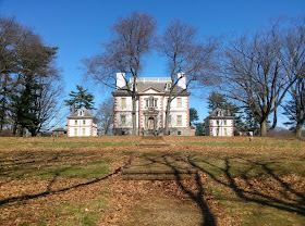
Mount Pleasant mansion as seen from the Boxers Trail, East Fairmount Park
Here are all the important details you'll need to enjoy your day hiking the East Fairmount Park woods trails:

Trailhead: You will find the start of the East Fairmount Park Woods Trails across the street from the north side of the Philadelphia Museum of Art, near the intersection of Kelly and Fairmount drives. As you stand on the corner you'll notice the begining of a faint dirt path that runs paralel to the west, between Kelly Drive and Pennsylvania Avenue. Parking in the art museum parking lot or find street parking. Or, you can reach the trailhead via the SEPTA 32 Bus from Center City, which stops near the corner of Fairmount Drive and Pennsylvania Avenue.
Distance: 4.5 miles one-way (9 miles out-and-back)
Elevation Gain/Loss: The trail has some ups and downs, but nothing more than about 30 feet.
Map: With the exception of the small portion of the Boxers Trail that is in the woods behind Mount Pleasant mansion, East Fairmount Park Woods Trails are not on any of the maps distributed by Fairmount Park. The good news, however, you can view the park in detail using Google Maps, and because the woods run along such a narrow footprint here, it is all but impossible to get lost.
Hiking Time: 1.5 to two hours one-way or 3-4 hour hours round trip, depending on your personal speed and how often you take breaks to enjoy the views.
Best Times to Hike: This hike can be done year round.
Difficulty: Easy

For more information on this hike or other hikes discussed in the blog HikeyHikey, feel free to leave a comment below. Check out my other blogs Man of Merit and MyFitLife2Day and HikingMegalopolis. Or contact me via my splash page at about.me/brian.schwarz.