Thursday, April 25, 2013

Hiking Philadelphia - Wissahickon Gorge White Trail

Wissahickon Valley Park is a gem among gems within Philadelphia's Fairmount Park System, the largest urban park system in the United States. Among the many highlights of this park is its geography. Here, the Wissahickon Creek has carved a gorge through the landscape as it flows southward toward the Schuylkill River, where the Pennsylvania Piedmont flattens to form the Coastal Plain. As a result, trails are secluded within the city, and bustling urban life is at once proximate and absent, making the park both amazingly accessible and surprisingly serene.

Statue of the last Lenni-Lenapi chief, at Council Rock, along the White Trail
There are four primary routes through the park - three dirt-and-stone foot trails and one flat and wide pedestrian path, a former auto route. The 4.5-mile White Trail is a single-track and sometimes wider route that follows a primarily north-to-south trajectory high above the east bank of Wissahickon creek. The trail begins at the north end of Seminole Avenue in Chestnut Hill and continues southward to a point along Park Line Drive in Germantown.

A rocky incline along the White Trail, high above Wissahickon Creek
The White Trail parallels the Orange Trail for the most part. The White Trail, or the "high trail" climbs up and down the walls of the Wissahickon Gorge and involves a water crossing at Cresheim Creek, making it a bit more strenuous than the longer Orange Trail, which, as the "low trail", sticks more to the creek's shoreline.

Along the way, hikers pass two statues - the Indian Statue immortalizes the last Lenni-Lenapi chief at Council Rock and the Toleration Statue is of Pennsylvania founder William Penn and harkens to his political leanings toward inclusion.

Rock-hopping across Cresheim Creek may become treacherous after rains
The White Trail is at some points heavily trafficked by dog walkers, mountain bikers and joggers, which takes away some of the joy of hiking that one feels along the more secluded Orange Trail, where mountain biking is mostly restricted. Still, it is a great fitness route, especially for folks in adjacent Chestnut Hill, Mount Airy and Germantown, as well as folks in South Philly and North Philly who can reach trailheads easily on SEPTA buses from the Broad Street Line's Erie Station or via SEPTA Regional Rail on the Chestnut Hill West line.

Dog walkers, runners, mountain bikers and hikers share the White Trail
Here are all the important stats you'll need to enjoy your day hiking the Wissahickon Gorge White Trail:

Trailhead: Take the SEPTA 23 bus to the intersection of Chestnut Hill and Germantown avenues, walk three short blocks down Chestnut Hill Ave., and you will see the trailhead on your right. You could also take Regional Rail to either Highland Station or Chestnut Hill West and follow the local streets to the trailhead at Chestnut Hill and Seminole avenues. (Check the SEPTA schedule here). The other trailhead is at Park Line Drive and Hortter Avenue, just a few blocks from Tulpehocken Station on the Chestnut Hill West rail line and two blocks south of the SEPTA 53 bus stop at Hortter and Wayne Avenue.
Distance: 4.5 miles one-way (9 miles out-and-back). Add a quarter mile to each end if taking transit.
Elevation Gain/Loss: Estimated 100-300 feet (30-90 m). The elevation change is 100 feet (30 meters), but the trail has a lot of ups and downs, so until I can get a GPS reading I've included an estimate here.
Map: Friends of the Wissahickon and Philadelphia Parks and Recreation have just put out a 2013 Map of the Wissahickon Valley Park, which you can pick up at several locations in and around the City of Philadelphia, including at the Valley Green Inn, along Forbidden Drive in the park. You will find more information about the map and where to get it here. Also, find information on the Wissahickon Gorge's geography and geology in this 1997 report.
Hiking Time: 2 to 2.5 hours, depending on your personal speed.
Best Times to Hike: This hike can be done year round, but snow and ice may impede enjoyment without snowshoes or crampons in the winter. Springtime is mud season, but you can avoid the mud by rock hopping. Avoid this hike after heavy rains, as the stream crossing may become treacherous at these times.
Difficulty: Easy to Moderate

Overuse on the White Trail has led to re-routing to protect habitats
For a more rugged experience in the Wissahickon Gorge, check out the Orange Trail. And for more information on this hike or other hikesdiscussed in the blog HikeyHikey, feel free to leave a comment below. Check out my other blogs Man of Merit and MyFitLife2Day. Or contact me via my splash page at about.me/brian.schwarz.

Saturday, April 20, 2013

Hiking Philadelphia - Wissahickon Gorge Orange Trail

When most people think of Philadelphia, it is unlikely that hiking comes to mind. But I'm hoping this post will change that! Philadelphia is home to Fairmount Park, the largest urban park system in the United States. And the gem of the Fairmount, in this blogger's opinion, is the Wissahickon Gorge Orange Trail.

Follow the orange blazes of the Wissahickon Gorge Orange Trail
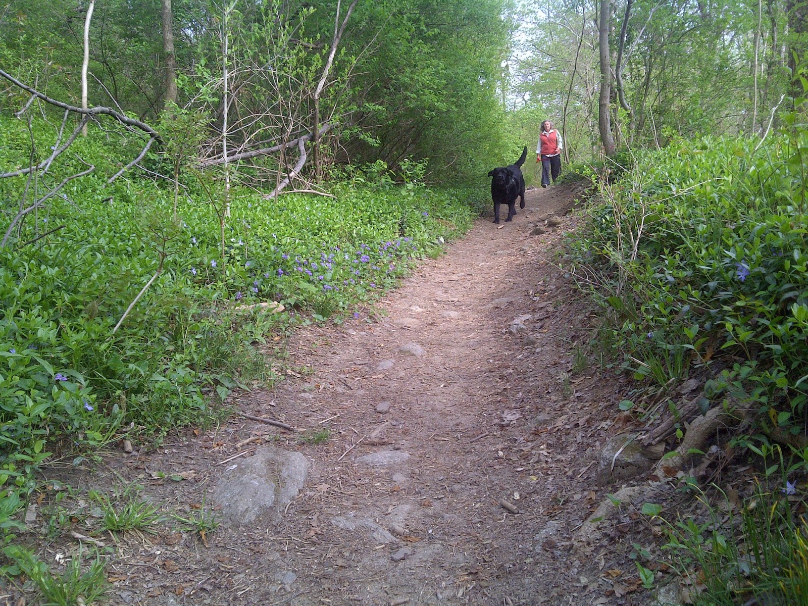
The Wissahickon Gorge Orange Trail is a rugged, single-track, dirt-stone-and-root-strewn path that follows the namesake creek's northern and eastern banks and along the lower gorge wall. Higher up the gorge wall, the White Trail follows a near parallel path. Forbidden Drive is the heavily traversed, wide and smooth, multi-use trail that follows the creek on its opposite shore. 

It's an enigma wrapped in a riddle, as they say. The wooded path that is the Wissahickon Gorge Orange Trail appears on maps to be too close to the city to be enjoyed as an apparent wilderness. Its location deep within the Wissahickon Gorge, however, makes it so. For at least two-thirds of the trail's length, the gorge is practically free of urban noise pollution (with the exception of the occasional scream of emergency vehicle). Otherwise, the sounds of the creek, birds chattering, and wind blowing through the canopy of trees are all you will hear along the Orange Trail.

Enjoy the lush riparian environment of the Wissahickon Gorge Orange Trail
The Wissahickon Gorge Orange Trail makes its way from the northwest reaches of the city, at Chestnut Hill College along East Northwestern Avenue, to the Schuylkill River, near the intersection of Lincoln and Kelly drives at the Wissahickon Transportation Center. This thru-trail is approximately 7.5 miles from start to finish, and it can be done in about 3.5 to four hours, depending on your personal speed.

You won't find outfitters in Philadelphia to shuttle you from one end of the trail to the other. So the best way to enjoy this trail is to reach the trailhead via public transportation, provided frequently, conveniently and economically by the Southeastern Pennsylvania Transportation Authority (SEPTA).

From the Olney Transportation Center (Broad Street Line Subway), board the L bus going west toward Plymouth Meeting and get off at the gates of Chestnut Hill College, at the corner of Germantown Pike and Rodgers Drive. The trail begins by crossing the south side of the bridge. From there, the trail veers to the right and hugs Wissahickon Creek, which will remain on your right hand side for the entirety of your hike. 

At about the half-mile point you will cross West Bells Mill Road, and just past the one-mile point you will arrive at a covered bridge. Built in 1737, this is the only remaining covered bridge of the many that once crisscrossed the creek in the area.

Covered bridge along the Wissahickon Gorge Orange Trail
Enjoy the many views of the bridge, then find your way back to the trail, which continues on the other side of the picnic area there. Within a half mile of passing the covered bridge, keep your eyes directed up the slopes of Wissahickon Gorge and you will see a statue of a kneeling Lenape warrior atop a large rock outcrop called Council Rock.

It is worth it to take the short connector trail up to the top of Council Rock to see the statue up close. According to the Friends of the Wissahickon's 2013 Map of the Wissahickon Valley Park, this 1902 statue stands "where the Lenape are believed to have held gatherings." 

Return to the Orange Trail, and the next mile or so past Council Rock is some of the most beautiful terrain you will encounter along the Orange Trail. There is a section with dozens of rhododendron bushes which, if you're lucky, you'll get to see in bloom. This, according to the National Rhododendron Society, occurs in the Philadelphia area from mid-May through the first week of June.

Civilization along the trail at Valley Green Inn - trail maps available here
At approximately 2.5 miles into your hike you will come across a bridge that gives you access to the Valley Green Inn, which has public restrooms for hikers as well as a restaurant with a full menu, making it a wonderful lunching spot along your hike. Even if you packed your lunch, I recommend you stop here for a cup of coffee to enjoy the view from the veranda. On a recent hike, I had a serendipitous encounter with a bald eagle and the Irish folk band Scynthian. (Read more about that here.)

Devil's Pool, along the Wissahickon Gorge Orange Trail
Continuing on, you will come across Devil's Pool at the three-mile mark. This is a spot of deep water along the Wissahickon, where it is joined by Cresheim Creek. Just beyond Devil's Pool, which is a popular spot for swimmers even though the official park policy bans swimming, you will reach the historic Livezey House (also known as Glen Fern).

From this point on the trail begins to feel a bit more civilized, especially at the 3.5-mile mark, where you encounter the Fingerspan Bridge, designed by artist Jody Pinto, which was airlifted into place by a helicopter in 1987.

Fingerspan Bridge, designed by artist Jody Pinto, along the Orange Trail
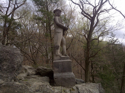
Another mile or so down the Orange Trail you will reach a sharp bend in the Wissahickon Creek. Just beyond the curve you will reach a rock outcropping called Mom Rinker's Rock, named after a reputed witch who, according to local lore, would drop balls of yarn containing messages about British troops to Colonial soldiers waiting below. A spur trail takes you to the top of Mom Rinker's Rock where you will find the Toleration Statue (placed here in 1883).

Tolerance Statue, atop Mama Rinker's Rock, Wissahickon Gorge
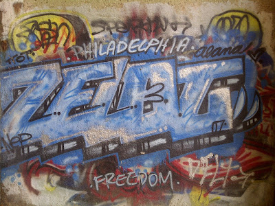
Just before the five-mile point you will cross under the Walnut Lane Bridge, which looms high above the creek. Enjoy the graffiti here and continue on. In another half mile or so you will reach historic Rittenhouse Town, which is home to several historic homes, the last remains of a bustling mill town established in 1690. 

At Rittenhousetown, you will follow the sidewalk uphill along Lincoln Drive to the intersection of Lincoln and Rittenhouse Street at the southern end of Saylor's Grove. Cross the drive here - carefully - and on the other side of Rittenhouse Street you will find the Wissahickon Gorge Orange Trail picks up to the right.

Graffiti at the Henry Avenue bridge, Orange Trail, Philadelphia University
This last portion of the trail, which continues south along the gorge high above Lincoln Drive all the way to its intersection at Ridge Avenue, is the least-traveled of the Orange Trail. In fact, the new map put out by the Friends of the Wissahickon no longer designates it with the Orange color - but to miss out on this portion of trail would be a mistake. One feels like a voyeur over the traffic below, and a sense of accomplishment mounts as you gently make your way back into civilization.

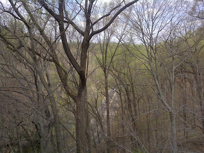
Lincoln Drive as seen from the Orange Trail, near Philadelphia University
Here are all the important stats you'll need to enjoy your day hiking the Wissahickon Gorge Orange Trail:

Trailhead: The start of the trail is near the gates of Chestnut Hill College. Take the L bus from SEPTA's Chestnut Hill West Station or the Broad Street Line's Olney Transportation Center and tell the driver you want to get off at the college on the corner of Germantown Pike and Rodgers Drive
(not all of the buses stop there, so check the SEPTA schedule here). Conversely you may start the trail from northeast corner of Lincoln and Kelly drives, which is accessible by a slew of buses and Regional Rail at Wissahickon Station.
Distance: 7.5 miles one-way (15 miles out-and-back)
Elevation Gain/Loss: Estimated 100-300 feet (30-90 m). The elevation change is 100 feet (30 meters), but the trail has a lot of ups and downs, so until I can get a GPS reading I've included an estimate here.
Map: Friends of the Wissahickon and Philadelphia Parks and Recreation have just put out a 2013 Map of the Wissahickon Valley Park, which you can pick up at several locations in and around the City of Philadelphia, including at the Valley Green Inn, along Forbidden Drive in the park. You will find more information about the map and where to get it here. Also, find information on the Wissahickon Gorge's geography and geology in this 1997 report.
Hiking Time: 3.5 to four hours, depending on your personal speed.
Best Times to Hike: This hike can be done year round, but snow and ice may impede enjoyment without snowshoes or crampons in the winter. Springtime is mud season, but you can avoid the mud by rock hopping.
Difficulty: Easy

Buses galore return to Center City from the Wissahickon Station
For another scenic hike higher up in the Wissahickon Gorge, check out the White Trail. And for more information on this hike or other hikes discussed in the blog HikeyHikey, feel free to leave a comment below. Check out my other blogs Man of Merit and MyFitLife2Day. Or contact me via my splash page at about.me/brian.schwarz.

Thursday, April 11, 2013

Hiking Little Rock Arkansas - Pinnacle Mountain State Park

Pinnacle Mountain juts skyward from the banks of the Arkansas River and Lake Maumelle in Central Arkansas, inviting hikers far and wide to scramble to its rocky summit. The easternmost peak of the east-west lying Ouachita Mountains, located just 15 minutes west of Little Rock, Pinnacle Mountain is a go-to spot for locals seeking fitness, fun and even spiritual renewal. It is also close enough to Interstate 40 to be a welcome leg-stretcher for cross-country travelers as well.

Pinnacle Mountain State Park - West Summit Trail rises along stony spine
From I-40, take Interstate 430 south two exits to Highway 10 west. Six miles down the road you will turn right on Chenal Parkway, which connects to Route 300, which will take you to the entrance to Pinnacle State Park. The parking area for the West Summit Trail is off of Route 300. To reach the East Summit Trail go a little farther and follow the turn-off that leads to the Pinnacle Mountain State Park Visitor's Center. 

West Summit Trailhead - with connections to Base and East Summit trails
Both the West Summit Trail and the East Summit Trail are about 1.5 miles round trip. The West Summit Trail has a slightly more gentle slope while the East Summit Trail requires a bit of scrambling (using your hands to scale larger boulders). You should be ready for a two-hour hike using either route, and take plenty of water. You could also make this a loop hike by taking one trail up and the other down and using the Base Trail to return to the trailhead from where you started.

Trail sign near the beginning of the West Summit Trail
The Base Trail makes a 3.5-mile loop around the mountain, and this is a great option for hikers not able to handle the approximate 600-foot elevation gain/loss to reach the summit. For the summit loop hike, taking the western portion of the Base Trail will make your summit experience into a 3.5-mile hike while taking the eastern portion of the Base Trail will make the loop a 3-miler. TIP: Taking the East Summit Trail to the summit and coming down the West Summit Trail may be easier if you sometimes experience vertigo.

Much of West and East Summit trails are rocky steps through boulder fields
Dogs are allowed to hike with their people, but they must be leashed at all times. Honestly, though, this can be a bit of a challenge, especially if you have a short leash or your dogs have short legs - as any hiker knows, navigating boulder fields is a personal experience. I have two small dogs and had to take them off leash so they could safely navigate the trail themselves. In fact, I had to carry one of my dogs as we reached the summit, where the boulders get a bit larger and more difficult to mount. I would not recommend you hike the East Summit Trail with dogs of any size. Still, if you do take your dog off leash make sure they are under voice command at all times, and of course re-leash them any time you come across other hikers on the trail.

Ouachita Mountains stretch west from Pinnacle Mountain's western spine
The views from the West Summit Trail, where the trail as your reach the summit follows the visible rocky spine of Pinnacle Mountain, are spectacular. The Ouachita Mountains stretch off to the west, with Lake Maumelle visible to the north of the chain. Once you reach the top, you notice that Pinnacle Mountain actually has two distinct summits linked by a saddle. the northern summit has spectacular views of the Arkansas River and Lake Maumelle, while the southern summit has a striking view of ripples of mountains rolling off into the distance.

Hiker enjoys the view from Pinnacle Mountain's rocky summit
On the east side of the southern summit you will notice the red/white blazes pointing you back down the East Summit Trail. Yellow blazes mark the West Summit Trail, while green blazes mark the Base Trail. It is impossible to get lost on Pinnacle Mountain as long as you keep your wits about you and pay attention to geographical landmarks the blazes marking boulders and trees along whichever trail you are on.

Red/white blazed entrance to East Summit Trail atop Pinnacle Mountain
Here are all the important stats you'll need to enjoy your day hiking Pinnacle Mountain:

Trailhead: From I-40, take Interstate 430 south two exits to Highway 10 west. Six miles down the road you will turn right on Chenal Parkway, which connects to Route 300. Take 300 to the entrance to Pinnacle State Park. The parking area for the West Summit Trail is off of Route 300. To reach the East Summit Trail go a little farther and follow the turn-off that leads to the Pinnacle Mountain State Park Visitor's Center.
Distance: 1.5 mile out-and-back hike for either West Summit Trail or East Summit Trail. Also, you may choose the 3.5-mile Base Trail Loop or make a summit loop of either 3 miles (east Base Trail) or 3.5 miles (west Base Trail).
Elevation Gain/Loss: 600 feet (183 m)
Map: You can find the Pinnacle Mountain State Park map here. I would also suggest checking out the GPX map posted by fellow blogger Arklahoma Hiker here.
Hiking Time: About 2 hours, depending on your personal speed.
Best Times to Hike: This hike is excellent year round.
Difficulty: Moderate


East Summit Trail Trailhead, the tougher of two routes to Pinnacle's summit