The gypsum and mineral-rich White Mesa belongs to Zia Pueblo but the trails here are maintained by the Bureau of Land Management. First developed for mountain biking, with its unique geographical features and historical significance, this magical place is growing in popularity among hikers - so much so that the BLM recently built a second parking lot to handle the flow, especially during the winter months when trails at higher elevations are covered with snow.
 |
| Hiking Zia Pueblo White Mesa Trails, near Ojito Wilderness, New Mexico |
To reach the trailhead, travel from either Albuquerque or Santa Fe on I-25 and take Exit 242 and turn left toward Bernalillo. Follow NM 550 West for about 20 miles, then turn left on Cabezon Road. You'll notice a big white mesa in front of you, and if you reach the town of San Ysidro you've gone about two miles too far. Almost immediately Cabezon Road veers to the left. Follow the signs for Ojito Wilderness/Zia Pueblo. From the turn-off, follow the rugged dirt road about four miles where you will cross a cattle guard. Park at the lot on the left side of the road. The trail head is directly across from the parking area on the right side of the road.
 |
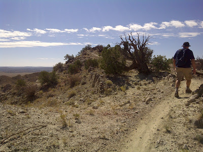
| A hiker heads into the painted canyon, which leads up to White Mesa |
The trailhead will lead you toward the mouth of a painted canyon, colored in light hues of blue, red and green by the various minerals that flow from springs nearby. You'll also notice a huge hunk of bright white gypsum clinging to the north wall of the canyon. This is where you will encounter your first elevation gain. While it's not very high, it's a bit steep and it can be difficult to get your footing. A walking stick helps, but it's still do-able without one. But be careful!
 |
| This is your first ascent and final descent - it's challenging but do-able |
Once you reach the top of the mesa you will notice you are at a clearing where it seems vehicle have been doing donuts in the white gypsum soil. Straight ahead you will see a trail map. Get your bearings and follow the points 17, 18, 19, 22, 12, 13, 15, 16, and back to 17. This may seem like gibberish, but take a look at the map pictured here and it will all make sense. At point 17 you are back at the clearing. You will descend the same way you came up - and it's a bit more precarious going down, so again, be careful.
 |
| Check out the views from the hike's high point on a solid gypsum hill |
Continuing along the trail described above, you will soon pass the highest point on this hike, at 6,060 feet elevation. Take in the amazing views. You will see the famous Cabezon Mesa sticking up on the horizon like a "big head". Also, notice the Jemez Mountains to the north, the Sandia Mountains back in the direction of Albuquerque and of course the basin that forms at the edge of the mesa with the Tierra Amarilla Anticline as its dramatic backdrop.
 |
| Pay attention to these junction signs to follow the loop described - or explore! |
Here is some information on the historic and geographical significance of the region, provided by the BLM:
At the western edge of White Mesa, the Tierra Amarilla Anticline forms high, narrow mesa ridges. This classic example of a plunging anticline is visited by several university field schools each year. Fossil remains of rare dinosaurs, plants, and trees from the Jurassic period are located in the Morrison Formation. Natural erosion processes have exposed the bones of huge dinosaurs and large segments of petrified trees. These fossils are approximately 150 million years old! The longest dinosaur ever recovered, Seismosaurus, was discovered only a few miles west of the bike trails area in what is now the Ojito Wilderness. Paleontologists and geologists use this great variety of life to construct geologic timelines and interpret climate changes over the earth’s history.
 |
| Tierra Amarilla Anticline provides stunning backdrop at mineral spring |
From the gypsum-capped high point you will follow the Center Spine Trail that will take you along a descending ridgeline into the valley. From here, it is easy to follow the trail straight up a hill in front of you to find some fascinating payoff - an active mineral-water spring and, just off the trail to the left and up some more, a sink hole left by a spring that has long dried up. Continue on the trail, which is an old jeep road, until you reach a point where the trail heads back to the right along another ridge. This trail - at Junction 12 - will lead you back to your starting point.
 |
| Center Spine rises up the mesa as seen from a cool sink-hole along the hike |
 |
| Take your time and really explore the Center Spine Loop at White Mesa Trails |
This truly is an amazing hike, and I highly recommend it, especially for novice hikers or for anyone looking for a nice conditioning workout in the great outdoors. Here are the trail stats:
Trailhead: On Cabezon Road, four miles from NM 550 just south of San Ysidro. From the turn-off, follow signs for Zia Pueblo/Ojito Wilderness down the rugged dirt road for about four miles where you will cross a cattle guard. Park at the lot on the left side of the road; The trail head is directly across from the parking area on the right side of the road. NOTE: There is a second parking lot a little further down which is where most of the mountain bikers who ride these trails begin their rides.
Distance: 4.5 miles
Elevation Gain/Loss: Estimated 300 feet/300 feet (twice)
Map: A free map is available from BLM
here. This entire area is also well marked and mapped at most if not all of the junctions.
Hiking Time: Depending on your pace and how much you spend wandering around, this hike can take about two or three hours. But take your time - there is much to explore, and it's pretty hard to get lost since it is so open and well marked.
Best Times to Hike: This hike can be brutal in the summer but any other time of the year it can be hiked any time of the day. Just make sure you wear a hat and apply sunscreen regularly, even in the winter.
Difficulty: Easy. With the exception of the first ascent I mention where you might need to use your hands for balance, there is no climbing or scrambling. But you can do this hike at a good pace and will get an excellent cardio workout.
 |
| Making my way along the final portion of trail back to Junction 17 |
Please let me know if you try this hike, and if you're planning on checking it out feel free to leave me a comment below with any questions you may have. I'm always here to help! Also, follow me on Twitter
@MyFitLife2Day, read my other blogs
Man of Merit and
MyFitLife2Day, and check out
my Hubs at the popular site for writers, HubPages!


Loved this hike
ReplyDelete